


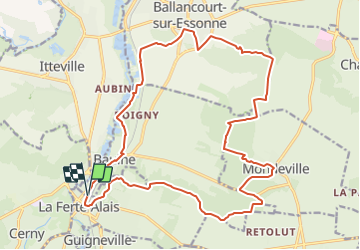
LA FERTE ALAIS - BOIS ET MARAIS

NUITEVEN
User

Length
22 km

Max alt
151 m

Uphill gradient
301 m
Km-Effort
26 km

Min alt
48 m

Downhill gradient
298 m
Boucle
Yes
Creation date :
2017-10-15 00:00:00.0
Updated on :
2017-10-15 00:00:00.0
5h37
Difficulty : Unknown

FREE GPS app for hiking
 SityTrail
IGN / Geographical institutes
SityTrail Plus
The world is yours!
About
Trail Walking of 22 km to be discovered at Ile-de-France, Essonne, La Ferté-Alais. This trail is proposed by NUITEVEN.
Positioning
Country:
France
Region :
Ile-de-France
Department/Province :
Essonne
Municipality :
La Ferté-Alais
Location:
Unknown
Start:(Dec)
Start:(UTM)
452053 ; 5370407 (31U) N.
Comments